Realistic Canadian Rockies Forest Map with Stream and Mountains
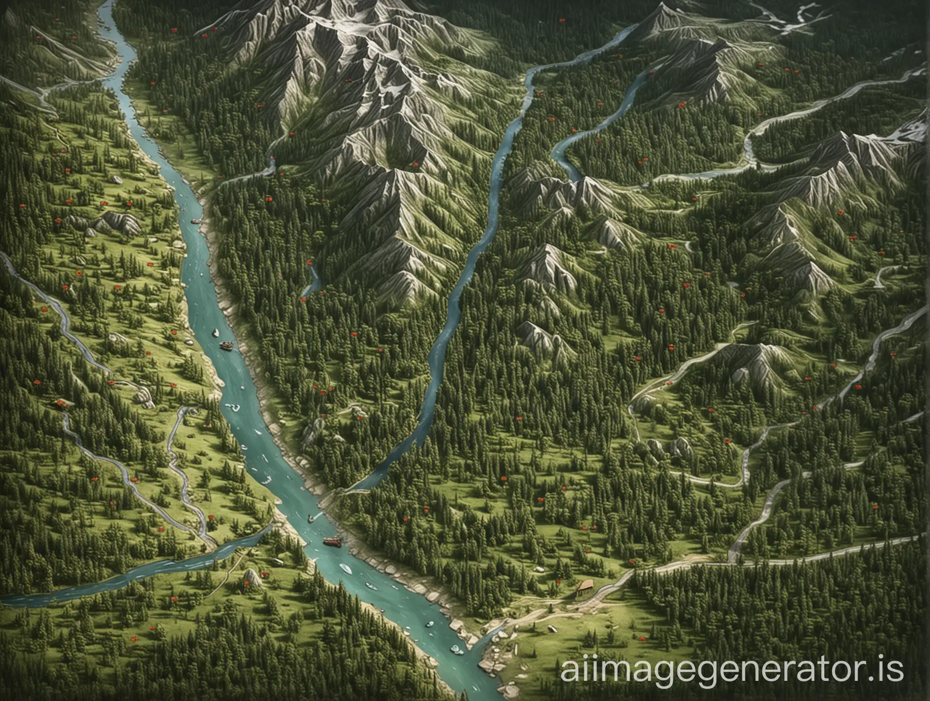
Image Prompt
Prompt
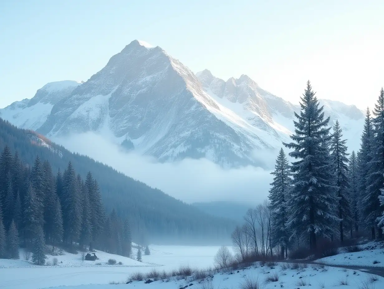
board game realistic forest map. the map should have the style and eatures of the canadian roocly mountains like by banff. it should be mainly forest with a lot of forest to walk though, but there is also a stream that goes through and maybe branches off. there is also a large mountainy area as well as a valley area. A dirt road travels through the map to connect all the major regions. covers quite a big distance that would take multiple days to trek through (maybe a 10km distance). the forest should be huge so that you can walk and walk and walk through it. dark evergreen forest. for the most part, each of the 4 main geological regions should have its own corner of the map. dont forget the mountains and valley regions as well as the dirt road that leads through all regions. it should be a dense forest.
the mountains should be like the canadian rocikes where the trees creep up half way the mouontain before it gets rocky and even snow on top. The valleys should be distinct as well. Remember: dense forest, moutains, stream, dirt road, and valley. it should seem almost like a birds eye view photo looking down on the canadian rockies. 20km distance
Model: realistic
Ratio: 4:3
Related AI Images

Related Tags
Prompt Analyze
- Subject: Setting Analyzing the setting, the image depicts a realistic representation of the Canadian Rockies, particularly resembling the Banff area. It features expansive forests dominated by dark evergreen trees, creating a dense and immersive environment. The presence of a winding stream, branching off in places, adds to the natural beauty and provides a focal point of movement and life within the scene. Subject: Geography The map covers a significant area, approximately 20km in distance, showcasing various geological features. It includes four main regions: dense forests that stretch endlessly, mountains where trees ascend halfway before yielding to rocky and snowy peaks, distinct valleys that contrast with the forested areas, and a central dirt road connecting all these elements. Each region is carefully detailed to reflect its unique characteristics. Subject: Style and Coloring The style emphasizes realism with a bird's-eye view perspective, aiming to capture the grandeur and scale of the Canadian Rockies. Colors are natural and muted, focusing on greens for the forests, grays and whites for the rocky mountains, and shades of blue for the stream, all blending to create a harmonious natural tableau. Subject: Action and Items The scene portrays a serene and untouched wilderness, inviting exploration and discovery. Imagery may include wildlife subtly integrated into the landscape, such as birds flying overhead or deer grazing near the stream. The dirt road suggests human presence without overpowering the natural elements. Subject: Costume or Appearance The landscape itself acts as the primary 'costume', featuring rugged terrain and pristine nature that are characteristic of the Canadian Rockies. The forest, mountains, and valleys are depicted with attention to detail, enhancing the viewer's sense of immersion and realism. Subject: Accessories Key accessories include the dirt road that winds through the map, serving as both a practical pathway and a narrative element that connects the diverse regions. Additionally, natural elements like fallen logs, small clearings, and patches of wildflowers add subtle details that enrich the overall visual experience.